Phone : 0800 470 3410
Phone : 0800 470 3410
By working with STM it has been possible to hone the Council’s initial assessment of flood risk by taking into account not only the likelihood of flooding, but also the cultural, economic, human health, and environmental consequences should it occur. In doing so it has been possible to identify localised hot spot areas of flood risk.
by Alys Bishop, Sustainable Drainage Engineer
To download this case study as a PDF click here
Central Bedfordshire’s Flood Team recently contracted STM to carry out a detailed analysis of the potential consequences of flooding in their district in order to inform their strategic flood risk management plan. The primary purpose of the project was to produce GIS maps that identified the areas that are most vulnerable to flooding from all sources.
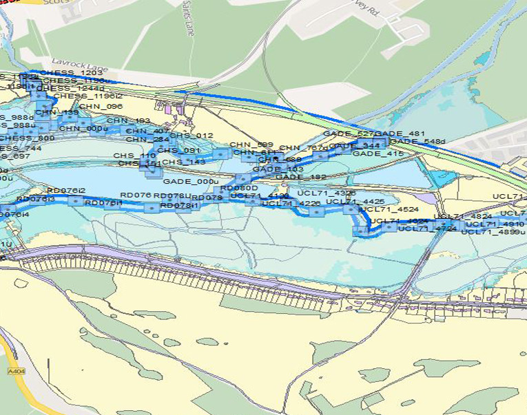
STM carried out the works using specially developed software (MapEagle) producing maps that went to a resolution of 50x50m grid areas, to allow Central Bedfordshire to target with almost pin-point accuracy the most problematic locations within their authority.

Central Bedfordshire is a diverse area with varied landscapes and geological formations, ranging from chalk in the Chiltern Hills, clay vales and floodplains, and the distinctive Greensand Ridge Valley. There is also an extensive network of watercourses, with the majority of the land draining to the catchment of the river Great Ouse (which discharges to the sea in The Wash) and a small area in the south draining to the catchment of the River Lea (which discharges to the Thames Estuary upstream of the Thames Barrage). Historic records show reports of flooding spread throughout Central Bedfordshire, with the highest number of incidents reported in the centre and northeast of the area.
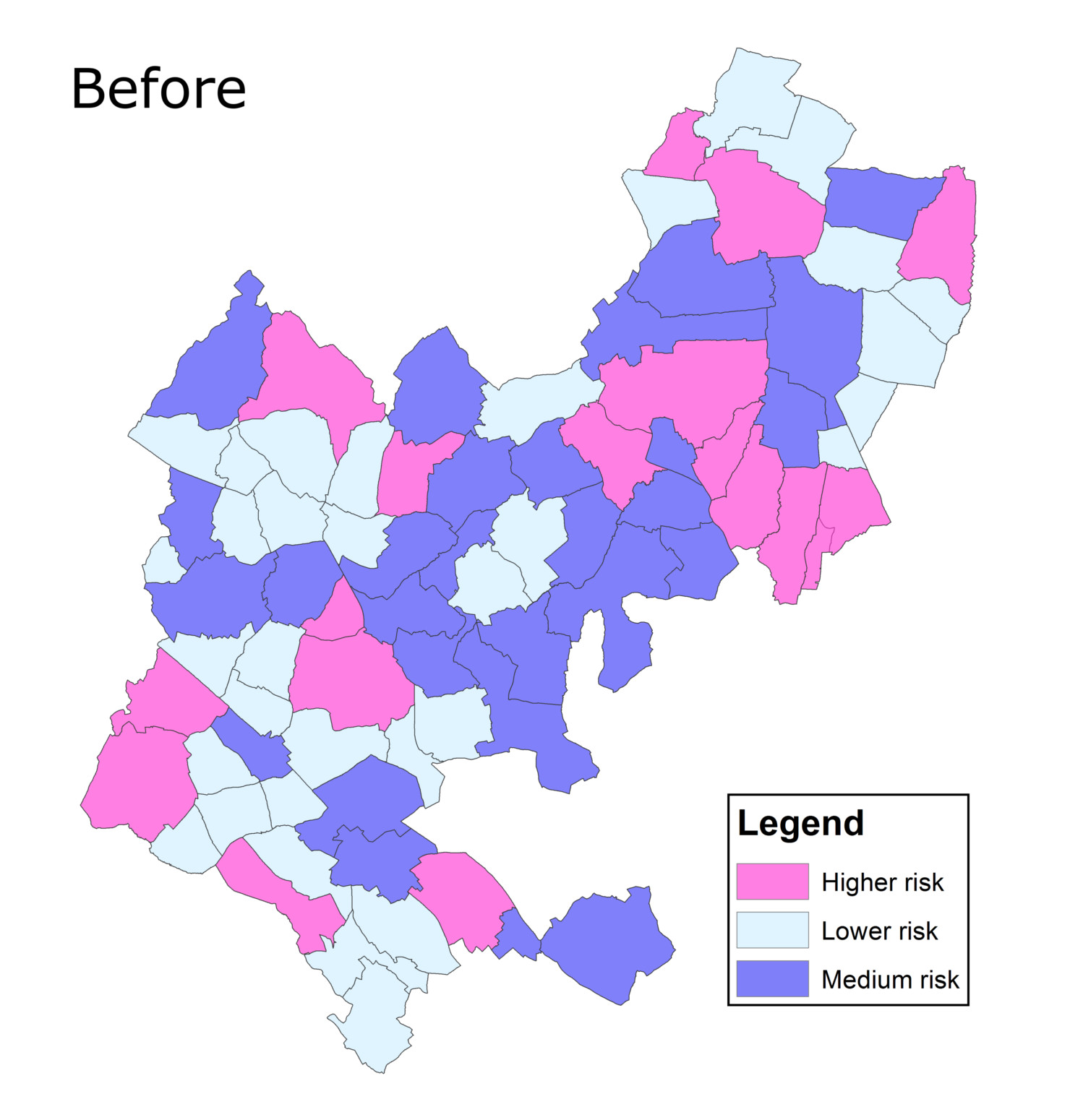
In February 2014, the Council adopted its ‘Local Flood Risk Management Strategy’ for Central Bedfordshire under the requirements of The Flood & Water Management Act 2010. As part of the development of the Strategy, and in order to better understand existing drainage problems, local knowledge together with national modelling was used to categorise the County into areas of ‘high’, ‘medium’ and ‘low’ risk of flooding. This saw 22% of all parishes marked as high risk, 36% as medium risk, and 42% as low risk.
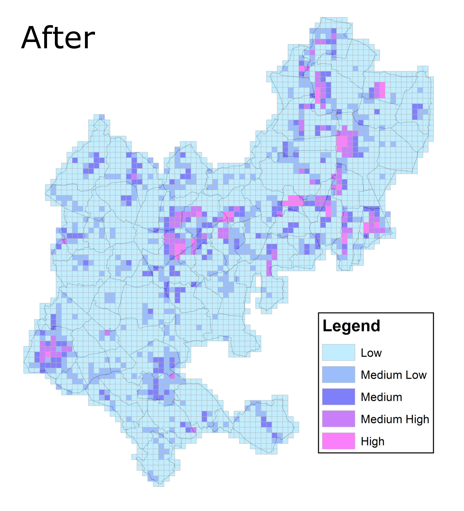
Having recently taken on additional responsibilities as a statutory consultee to planning on surface water and SuDS, whilst also continuing to deliver the wider duties imposed on the Council as a Lead Local Flood Authority, CBC wanted to refine its current assessment of risk at the parish boundary level to provide an enhanced oversight of flood risk at the local level.
By working with STM it has been possible to hone the Council’s initial assessment of flood risk by taking into account not only the likelihood of flooding, but also the cultural, economic, human health, and environmental consequences should it occur. In doing so it has been possible to identify localised ‘hot spot’ areas of flood risk.
The assessment was made by splitting the county up into grids and counting the number of features on each receptor layer (i.e. the consequences listed above) that intersected with features within flood hazard layers within each grid (flooding from rivers and seas, surface water and groundwater). Each time a receptor feature was found to intersect a hazard feature, the score associated with the risk class for the flood hazard feature was added to the receptor score (RS) for the grid. Each receptor type was assigned one or more Receptor Threshold Scores (RSTS), designed to flag up potential flooding hotspots. If the RS is equal to or greater than the RSTS, then the grid is assigned a Relative Priority Score (RPS), which was used to prioritise the different potential impacts against each other. All the RPS’s received by the grid are then added together to obtain the Overall Priority Score (OPS) for the grid. This methodology was based on the CIRA document Framework and tools for local flood risk assessment: project report SC070059/R3.
In identifying the hot spot areas it will be possible for the Council to focus on, but not be limited to, reducing the flood risks in these areas and identify through the Local Strategy’s ‘Action Plan’ strategic opportunities to investigate, collaborate and take action in order to mitigate a range of flooding problems in the short, medium and longer term.
In summary, the outputs of STMs hot spot mapping will assist the Council in:
STM provided consistently helpful and high quality advice throughout the mapping project. Project Manager Simon Makoni demonstrated the data throughout the different stages of the project, taking into account the needs and future use of the data by CBC. Using STM has helped us establish more refined and robust flood risk management data for our wider work as lead Local Flood Authority.